

")


Visit the Work Site Virtually with Oblique Imagery

By Nearmap.
Obliques provide better in-field perspectives and increase the ability to take measurements from afar.
Oblique imagery is available from Nearmap that allows contractors to review jobsites using high-resolution aerial imagery. Do all of this and more from the comfort of your own home or office.
The benefits of going oblique:
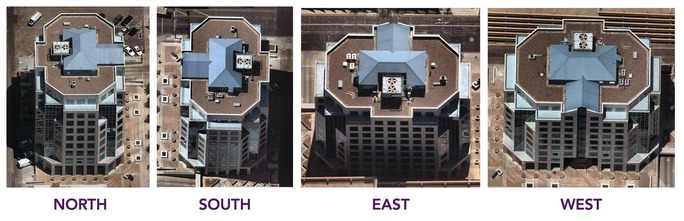
Beyond vertical or ortho aerial imagery, obliques provide a distinct advantage when it comes to visualization: seeing a project site from multiple directions. No need to worry about tree cover, building eaves, or other structures impeding your line of sight. Because our oblique imagery is captured at a 45-degree angle, you get better in-field perspectives with HD location content.
Access to oblique imagery means you can view your work site virtually, without setting a foot on the ground. Explore the natural environment and assess needs and opportunities of a work site with increased clarity and accuracy to better streamline your project management.
One of the key benefits of Nearmap Oblique is the ability to take measurements—confidently. Avoid costly rework or better gauge project resources by measuring building height and width for safety, compliance and structural requirements.
Nearmap also flies proactively across major urban areas in the U.S. What does this mean for you? You’ll have access to the latest and greatest aerial content, refreshed regularly with captures happening up to three times per year. Compare and contrast seasonal changes and improve your project maintenance and management with leaf-off/leaf-on captures.
Historical, accurate, measurable and up-to-date aerial content—what more could you want?
Nearmap captures urban U.S. imagery multiple times per year, processes massive amounts of visual data, and uploads up-to-date aerial maps to the cloud within days. How? Powerful, patented imaging and processing technology. Their unique speed allows Nearmap to deliver high-resolution aerial imagery as a service: orthographic (vertical) maps, new multi-perspective oblique views and 3D models. Continuous innovation is key, as each advance unlocks greater detail, value and opportunity. Contractors can rapidly scale their business through reliable, updated high-resolution imagery. With Nearmap roofing estimators can be everywhere without going anywhere.
Learn more about Nearmap in their RoofersCoffeeShop® Directory.
Recommended For You

Get Familiar With AccuLynx's Updated Photo Features
Read More ...
New Duplicate Records Functionality Makes Your Jobs Run Smoother and Faster
Read More ...
Slip on a steep roof leads inventor to build remote inspection robot
Read More ...


Comments
Leave a Reply
Have an account? Login to leave a comment!
Sign In