


New Nearmap Project Tool Enhances Updated Maps

Introducing Nearmap Projects
We’re excited to announce the latest upgrade to the MapBrowser web interface: Projects. Projects is a major feature enhancement that allows you to create, manage, and save custom projects with aerial imagery in Nearmap, without having to export imagery into an external application. Now your critical site planning and design can take place entirely on the Nearmap platform, simplifying your workflow and allowing you to gain faster, deeper insights from high resolution imagery.
Projects is a perfect solution if, like many professionals, you're spreading their workflow thin across multiple design apps and would benefit from consolidation.
Projects Streamlines Your Site Planning & Design Work
The Projects tool was designed to help you streamline the way you work with aerial views. In particular, Projects lets you:
- Save your work. Previously, the only way to save measurements and annotations on Nearmap imagery was to export a screen capture. With Projects, you can create, name, and save plans and layouts, so you can return to and revise your work whenever you like. Projects even autosaves your work as your project evolves, and lets you save an unlimited number of projects in your Workspace.
- Keep tabs on your most important projects. Easily sort & save projects with custom tags, so you can keep track of projects by client name, project ID, status, project lead, location, etc. View all your projects in a single dashboard, and archive lower priority projects that don’t require frequent monitoring.
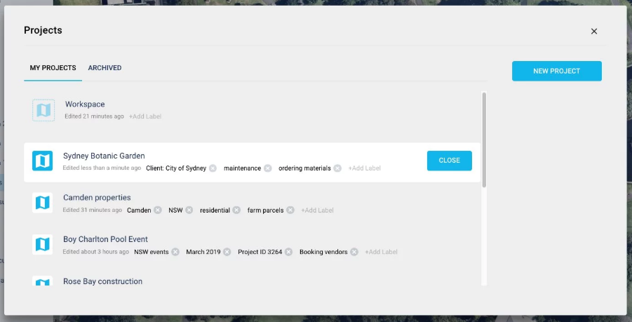
- Make individual or aggregate measurements. Projects lets you measure line, area, and radius of individual objects and ground features, just as you could in previous versions of MapBrowser. Even better, you can now take aggregate measurements of multiple objects or features. Need the total area of individual car parks in a stadium layout? No problem, Projects can measure and store that data for you. Want to understand how much soil you’ll need to fill in multiple garden beds on a new landscaping job? Projects is your tool.
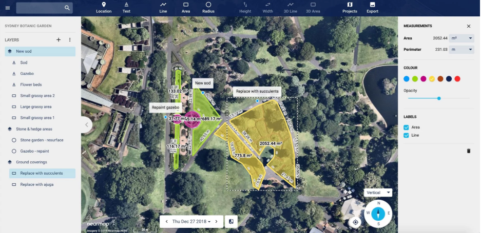
- Organize site features in layers. When analyzing or mocking up a design for a new site, it can be helpful to organize similar features and objects into groups — for instance, the locations for all the food trucks at an event venue, or all heavy vehicle access points on a new construction site. Projects lets you mark and save these objects into layers so that you can easily understand important aspects of your project. You can even turn layers on and off, making it easy to visualize important site attributes.
- Style site objects for easy visualization. Projects comes with a basic color palette and opacity slider that you can use to style and organize objects on your site. Customize your view and understand your site at a glance with easily identifiable objects and features.
 Nearmap product manager for apps Tash Ridley is looking forward to seeing how people will incorporate Projects into their workflow. "It's been great to build a feature that so directly responds to our customer's needs," Ridley says. "Our customers have told us that they would like to do more of their planning with our imagery, without needing to rely on external design and layout tools. The new Projects tool means customers can easily and quickly create an accurate and visually engaging layout for all of their projects."
Projects is the Custom Design & Planning Tool of Choice for Any Professional Managing Outdoor Work
Professionals who need to apply design and planning tools to high resolution aerial imagery will find Projects a vital new part of their digital toolbox.
Landscapers
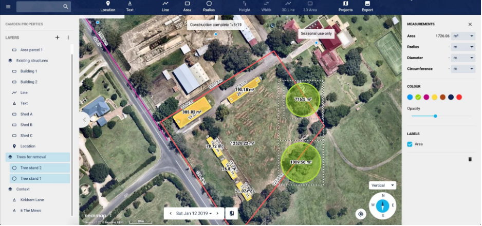
Landscaping design and maintenance companies can use Projects to get a complete picture of their project area for more accurate design, quoting, and labor management.
Nearmap customer Elite Grounds has already begun incorporating the Projects tool into their workflow.
Cameron Ashby, systems manager at Elite, says, "I love the auto sum of the layers in the Projects tool. And the ability to change colors. And the export of high-res imagery we can do for the site." Ashby sees a huge upside in using Nearmap for landscaping job quotes. "It has easily made me at least 50% more efficient," he explains. "It helps us bid on newer projects that have been built in the last six to 12 months faster and more accurately. This way we don't have to hire extra personnel just to go out and measure these properties by hand."
Projects also helps landscapers:
- Calculate materials requirements: Gather aggregate area measurements to estimate necessary amounts of sod, mulch, and plants.
- Determine maintenance layout: Position sprinkler heads for optimal watering setup.
- Identify and save critical site elements: Trace and save driveways, flower beds, trees, garden walls, storm drains, and other critical site objects.
Property & Real Estate Developers
Projects aids in the scouting, assessing, and marketing of properties by letting developers analyze the property’s surroundings to allow for more informed investment decisions.
A property developer could use Projects to:
- Save parcels under development and notes about the surrounding area: Even properties lacking proper addresses are easy to save and return to in Projects.
- Monitor a site through the entire project lifecycle: Track changes over time in the surrounding areas for future investment potential.
- Enhance your presentation to wow investors: Identify site features by applying different colors to site objects and property boundaries to communicate the property’s value visually. Turn layers off and on to highlight particular features.
- Plan placement of marketing signage: Optimize sign placement by annotating areas of greatest visibility, as well as zoning regulations that may affect sign sizing and volume.
Pavers
Projects paves the way for asphalt designers to assess and plan a project site from the convenience of their office.
A paver could use Projects to:
- Adjust plans and designs on the go: Designers can return to a project as many times as necessary until the final design is ready.
- Predict materials requirements: Measure individual and aggregrate areas and distances to determine paving material needs.
- Annotate potential risks: Mark areas of concern identified in historical imagery such as deterioration or environmental change, and leverage the color palette to highlight cracking, previous maintenance, and environmental impacts.
- Monitor quarries and supply levels: Add multiple layers to a project to illustrate the differenty types of materials required for the job.
Designers & Builders
Designers and builders can take advantage of the pre-design and analytical capabilities of Projects to mock up early plans on high resolution imagery, before moving to the CAD design phase.
Designers and builders could use Projects to:
- Measure and highlight important logistics: Accurately plan crane and other heavy machinery placement using the client’s radius and lifting-load specifications.
- Communicate clearly with contractors: Identify, measure, and annotate overhead obstructions, site access points, and key features for inspection to clearly communicate with contractors before they arrive on site.
- Plan equipment routes and access points: Measure and annotate areas for heavy haul equipment, heavy loads, and high clearance needs.
Event Managers
Projects supports pre-production by reducing the need for costly site visits and creating insights into critical site details to jump-start logistics and design plans.
Event planners could use Projects to:
- Create site plans to transform outdoor space: Gain contextual understanding by annotating and measuring key details of interest: footpaths, trees, walls, exit routes, etc.
- Scope initial design and logistics layout: Outline and notate important site features like stadiums, platforms, press areas, restrooms, emergency vehicle parking, entry and exit points, and adjacent property that can be repurposed for parking.
- Give stakeholders a clear picture of event plans: Draw boundaries to signify various event zones and use layers to show or hide these areas.
FAQ
Why can’t I see the new Projects feature when I log into MapBrowser?
Projects is only available in the new MapBrowser at https://apps.nearmap.com/maps. You can also find more information about accessing the new MapBrowser here.
Will I use my data allowance when I use the Projects tool?
When you open and work within a project, you are browsing Nearmap imagery. As you pan and zoom on the map, your data allowance will be used in the same way as it is when you are viewing Nearmap imagery outside of a project.
Is there a limit to how many projects I can have?
At this time, individual users may have an unrestricted number of projects.
How many layers can I create in a project?
At this stage, there are no limits to how many layers you can create in a project.
What is a Workspace? How is it different to a Project?
Think of the Workspace as a blank canvas — you can search for a location, browse imagery, and create measurements just as you would normally do. Everything you create in the workspace will be saved automatically, so if you happen to refresh your browser, you won’t lose your work.
Projects are individual map views with measurements and annotations that you can easily revisit at any time; think of them as individual documents. Projects can help you organise and manage your work more easily by allowing you to save information about different jobs or sites that you are working on, and need to revisit.
How can I save my Workspace as a project?
You can easily save your Workspace as a project. Just click on the Projects icon in the toolbar and select Save as Project next to the highlighted Workspace.
Can I work on my project while offline?
It is not possible to access Nearmap imagery via MapBrowser in an offline mode. As you are working on MapBrowser in real time, Projects can only be accessed and worked on when you have an internet connection.
Can I share a project with someone else?
The Projects tool is currently restricted to individual projects. It is not possible to share your project with other users.
Why can’t see my projects on mobile?
Currently, Projects is only available on desktop and tablet devices.
How do I hide / unhide layers?
You can easily hide or unhide layers by clicking on the “eye” icon next to the layer name in the lefthand tool panel.
Still have questions?
Looking for more information about Projects? Check out the full product documentation.
Source: Nearmap
Recommended For You

Could Your Team Handle MORE Service Calls?
Read More ...
Centerpoint Connect expands roofing software app with new inspection capabilities
Read More ...
The Must-Have App for your Roofing Business
Read More ...


Comments
Leave a Reply
Have an account? Login to leave a comment!
Sign In